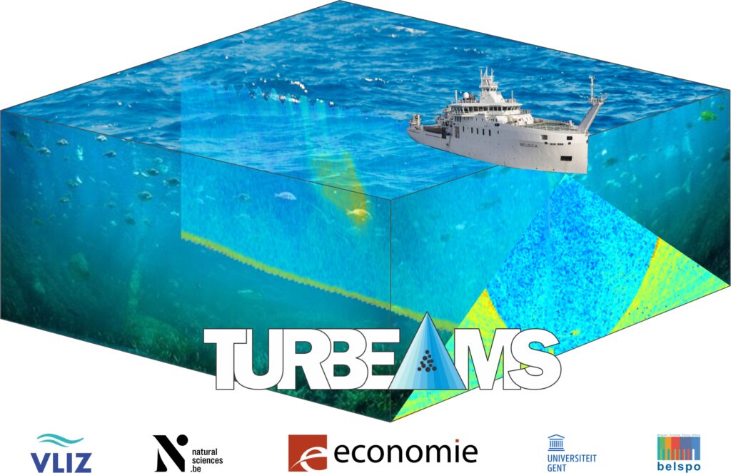
TURBEAMS: 3D turbidity by correlating multibeam sonar and in-situ data
Contact: thomas.vandorpe@vliz.be
Read more
Turbidity (or the cloudiness of water) is related to the concentration and type of particles in the water column. These particles may be either plankton or sediment. Combined they form a cloud of suspended particulate matter (SPM) which affects light penetration in coastal waters. Imaging these clouds of particles happens either in 1D or 2D at the moment, although research shows their shape is complex and variable. Within Turbeams, multibeam sonars are used to obtain a 3D image of turbidity and SPM, allowing to capture this complex and variable shape. On top of that, the multibeam water column data are compared to a large amount of datasets obtained within the water column, allowing to find out what kind of information is stored within the multibeam water column data and how we can used them to derive correct information related to the water quality.
Living lab: feasibility study for aquifer thermal energy storage on campus Ardoyen, UGhent
Read more
Assessment of fresh groundwater discharge in the Belgian coastal area
Contact: Marieke Paepen
Read more
Due to the equilibrium between in-land freshwater aquifers and seawater intrusion, coastal areas experience discharge of freshwater into the seas. This fresh submarine groundwater discharge (FSGD) generally occurs in a zone ranging from the intertidal zone to several tens to hundreds of meters offshore, depending on the (hydro)geological conditions. The quality of groundwater discharge is of uttermost importance as it is the entry gate for nutrients and pollutants in coastal ecosystems. Given its location at the interface between land and sea, fresh groundwater discharge has been largely understudied by the scientific community, since it requires a multi-method approach.
In this project, FSGD is characterized through a multidisciplinary approach. The fresh- and salt water interface is studied using geophysics (Paepen et al., 2020; 2022). Measurements are taken both on- and offshore to be able to image the full zone of groundwater outflow. A hydrogeological model is set-up for the De Westhoek area, which is calibrated based on these geophysical observations, allowing to predict the evolution of the groundwater fluxes due to climate changes and anthropogenic stress factors (e.g., pumping).
This project has received funding from VLIZ (Brilliant Marine Research Idea 2018), FWO, and the King Baudouin Foundation (Van Autenboer grant 2020).
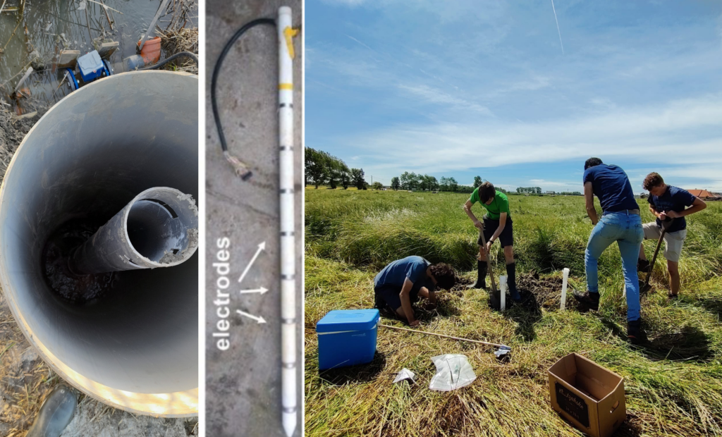
GeophySal: Time-lapse geophysical assessment of field scale water harvesting techniques to mitigate soil salinization in the Belgian Polders
Contact: Guillaume Blanchy
Read more
Polders are areas reclaimed on the sea thanks to hydraulic structures like dikes. To prevent flooding, these low-lying areas are constantly drained by a network of ditches that release excess water in the sea (e.g., at low tide). The use of subsurface drainage pipes connected to existing drainage ditches further enabled the drainage of the lands and made them suitable for agriculture. While the groundwater remains saline water from its seaborn nature, with years and precipitation, a freshwater lens, lighter than the deeper saline water, developed near the soil surface, on top of the saline water. This freshwater lens is essential for most conventional crops that would suffer from saline conditions. The thickness of freshwater lenses varies throughout the year as a function of the recharge from rainfall and evapotranspiration.
However, intensive rainfall events and prolonged summer droughts are becoming more frequent with Climate Change and lead to decreasing freshwater lens thickness, endangering crop yield. Controlled drainage systems that enable to regulate the water level in the subsurface drains have the potential to mitigate this issue by imposing a temporary higher water level, hence increasing recharge of the freshwater lens.
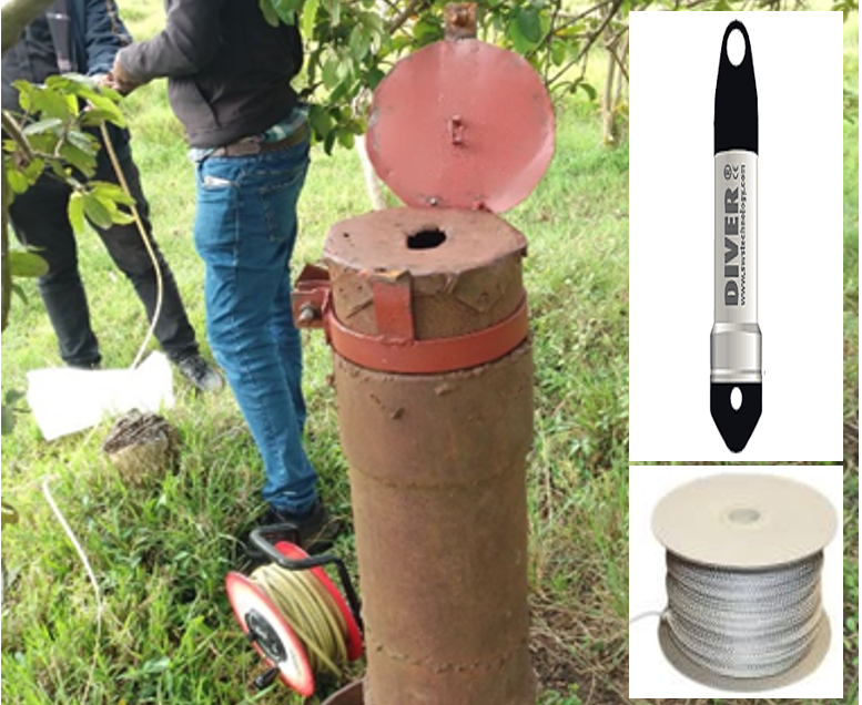
To better understand the dynamics of the fresh/saline water interface throughout the year, we equipped two fields with multilevel piezometers with both head and salinity sensors replicated three times in each field. Along each multilevel piezometer we also installed 1D resistivity sticks with 16 electrodes to obtain a vertical electrical resistivity profile. In addition, electromagnetic induction surveys enabled us to expand the local observations to the entire area (4 ha in total).
The datasets collected in the two fields in the conventional scenario (i.e. without controlled drainage) during the first year, showcase the usual dynamics of the interface, its lateral as well as vertical variability. The use of geoelectrical techniques enables us to distinguish fresh and saline water boundaries and its variability per soil layers. The electromagnetic induction surveys reveal old paleochannels that influence the dynamics of the freshwater lens at the field-scale. Moreover, the dataset also demonstrates how different crops (grass and flax) lead to different ground water and salinization dynamics.
More info on: https://www.peilgestuurdedrainage.be/

Mechanisms of rockmass instability in co-mining of deep mineral and geothermal energy considering spatio-temporal distribution of stress and temperature
Contact: Le Zhang
Read more
The high geological stress field and high temperature observed at large depth result in a complex and uncertain engineering environment for developing deep mining projects. It severely restricts the safe and efficient mining of minerals and geothermal resources. A better assessment of the temperature and stress field is thus essential. Firstly, considering the uncertainty of subsurface parameters, the distribution of the temperature field will be evaluated based on numerical simulations and in-situ tests, using a new framework called Bayesian Evidential Learning. The most sensitive parameters for deep mining will be identified and the heat storage capacity of the ground will be evaluated. Secondly, a model of the wave velocity field in the mining area will be established by combining external active source and internal micro-fracture source of the rock mass. Based on this, the dynamic change the wave velocity field under the coupled action of geothermal and mining exploitation will be systematically analyzed. Finally, the evolution of the stress field deduced from temperature and wave velocity fields will be predicted, in order to forecast the risk of rock failure in the deep mining environment. This project will provide theoretical and technical support for the safe and efficient mining of deep minerals and geothermal resources.
This project has received funding from FWO.
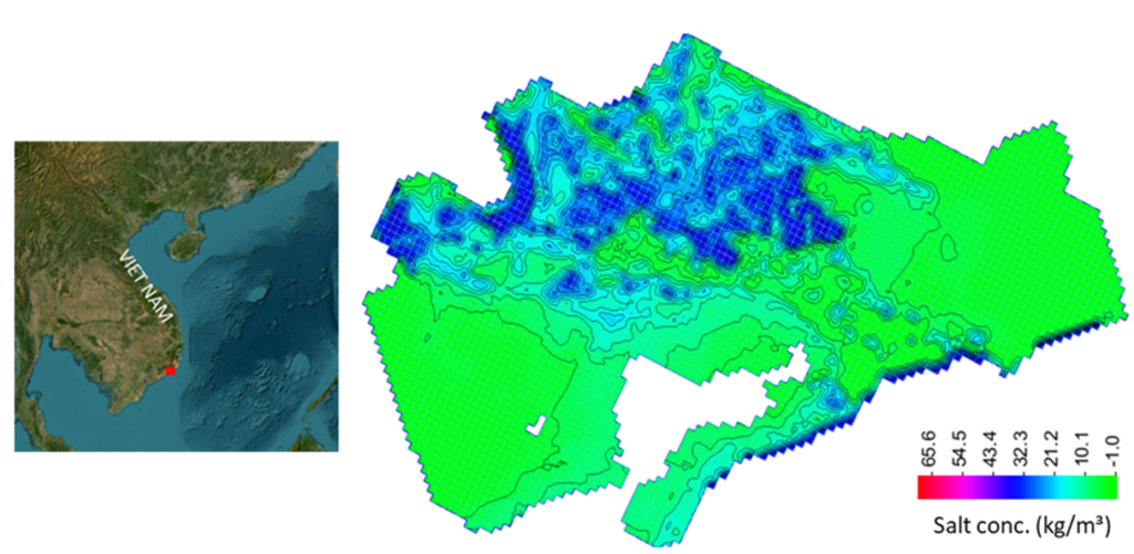
Impact of saltwater intrusion on water resources and irrigation in the Southern Central region of Vietnam under climate change
Contact: Linh Pham Dieu
Read more
This project aims at strengthening research capacities and providing scientific databases and management solutions for the sustainable exploitation and utilization of groundwater resources for the agro-food sector in the Southern Central region, thereby contributing to climate change mitigation and the sustainable socio-economic development of the region.
In terms of this project, new geophysical and hydrogeological data was collected in Binh Thuan, Vietnam. During this field work, including the ERT investigation and measurements of the water table and salinity, groundwater samples were collected for a full geochemical characterization. Automatic monitoring sensors were also installed.
In this research Linh evaluated the current salinity and freshening situation in the south-central region of Vietnam and built a conceptual model of the saltwater intrusion and freshening processes.
Currently, Linh is working on a groundwater model for the Luy’s River catchment in Binh Thuan province. In this study, the flow of groundwater with different densities is simulated to find out how aquifer properties affect the freshwater and saltwater distributions and to verify numerically the hypothesis behind the hydro-chemical conceptual model, i.e., to see if the time scale of the freshening and saltwater intrusion processes fit with the hydraulic properties and water balance in the catchment under the natural conditions. A groundwater model is simulated using SEAWAT based on the characterization of hydro-stratigraphic, the hydraulic parameters and boundary conditions distribution in the study area.
This project has received funding from VLIR-UOS since 2019 (VN2019TEA494A103).

Hydrogeophysical characterization of saltwater intrusions in the Southern Central Region, Vietnam
Contact: Diep Cong-Thi
Read more
The lithological and stratigraphical heterogeneity of coastal aquifers has a great influence on saltwater intrusion (SI). This makes it difficult to predict SI pathways and their persistence in time. In this context, a combination of both laboratory and field geophysical methods including electrical resistivity tomography (ERT), (spectral) induced polarization (SIP, IP), and electromagnetics (EM39) was used to discriminate the presence of saltwater-bearing and clayey sediment layers. Moreover, these techniques were carried out in many phases to assess SI based on both the presence and absence of co-location data.
For the first phase, the fresh- and saline water interface was observed in the inversion imaging to the expanding extent toward inland on the left side of the Luy River, but narrower boundaries on the opposite side where huge sandy dunes are located (Diep Cong-Thi et al, 2021). The clay-rich sediment lenses/ layers heterogeneously distributed in the saline zones are clarified in the following phases.
This project has received funding Vlir-uos through the TEAM project VN2019TEA494A103.

Improving aquifer thermal energy storage systems design through advanced hydrogeological uncertainty quantification (ATES2.0)
Contact: Luka Tas
Read more
Shallow geothermal energy is a sustainable, locally available alternative to provide heating and cooling to buildings. Groundwater is used to store the excess heat of buildings in summer in the subsurface with pumping and injection wells. In winter we can extract it again to heat the building in a green and sustainable way while storing cold for air conditioning in summer. In this way the subsurface acts as a kind of heat source or sink. These aquifer thermal energy storage (ATES) systems can potentially reduce CO2 emissions by 30% compared to conventional systems and can therefore be significant contributors to the energy mix. Along with the green and sustainable nature of this system, the currently rising energy cost drives the increasing interest in ATES. This will add more stress to our valuable subsurface system and more complex aquifers will become a target. The use of shallow geothermal energy is well known, however, there will be a need for a more thorough understanding of the scale and magnitude of the decision involved as well as optimization under uncertainty.
The objective of this research is to improve the design of shallow geothermal systems and predict the uncertainty of their energy efficiency using a stochastic framework called Bayesian evidential learning (BEL). The method will be validated at a spatiotemporal scale relevant for ATES
systems using two in-use systems and mimicking sparse data faced by companies and practitioners. ATES2.0 will be able to handle the currently growing complexity of data and models and it will offer a thorough and accurate methodology for proper natural resource management.
This project has received funding from BOF (Ghent University special research fund) and FWO.
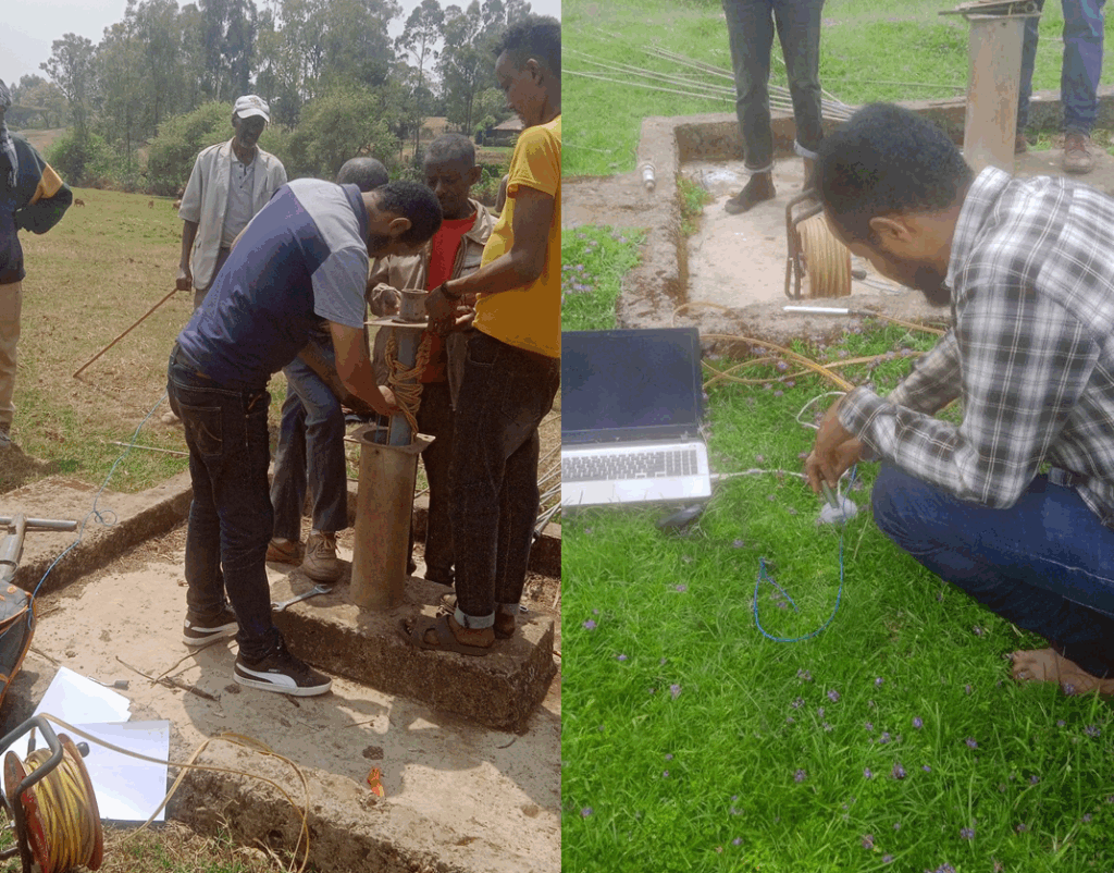
Groundwater potential assessment and recharge-discharge systems in southwestern Ethiopia
Contact: Adisu Befekadu Kebede
Read more
Groundwater is a vital natural resource, and understanding its potential, as well as the intricate dynamics of recharge and discharge systems, is crucial for sustainable water management. Groundwater potential assessment involves evaluating the capacity of an area to yield usable groundwater. This assessment considers geological formations, hydrological conditions, and human activities impacting aquifers.
Approximately 80% of water utilization in the southwestern region of Ethiopia relies on groundwater for both urban and rural needs, including drinking water and irrigation. However, there is limited detailed knowledge regarding the groundwater potential, encompassing key aspects like aquifer productivity, recharge-discharge mechanisms, and chemical attributes.
The research objective is to evaluate and quantify the groundwater potential while analyzing the recharge-discharge systems within the Gilgel Gibe and Upper Dhidhessa catchments situated in southwestern Ethiopia.The integration of various methodologies, such as desk studies, fieldwork, laboratory analysis, and software-based interpretation, indicates a well-rounded approach for sussfull of this work . Additionally, collecting primary and secondary data, including groundwater level data from data loggers and manual collection, highlights the dedication to gathering diverse sources of information. In this study, we will utilize two primary methods for estimating recharge: the Water Table Fluctuation and Chloride Mass Balance techniques. These approaches rely on groundwater level observations, rainfall data, and hydraulic properties such as the specific yield of the local aquifer system.
By comprehensively studying groundwater potential and the recharge-discharge system, we can develop strategies for sustainable water resource management, ensuring reliable access to clean water while preserving the health of aquifers and the ecosystems they support. Groundwater information will be disseminated to the decision makers so that they will be informed, and emphasis will be given to such limited resources.
This project has recieved funding from BOF (Ghent University Special research Fund for developing countries).
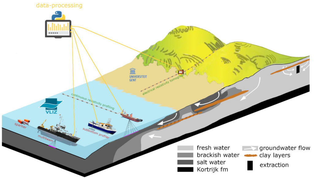
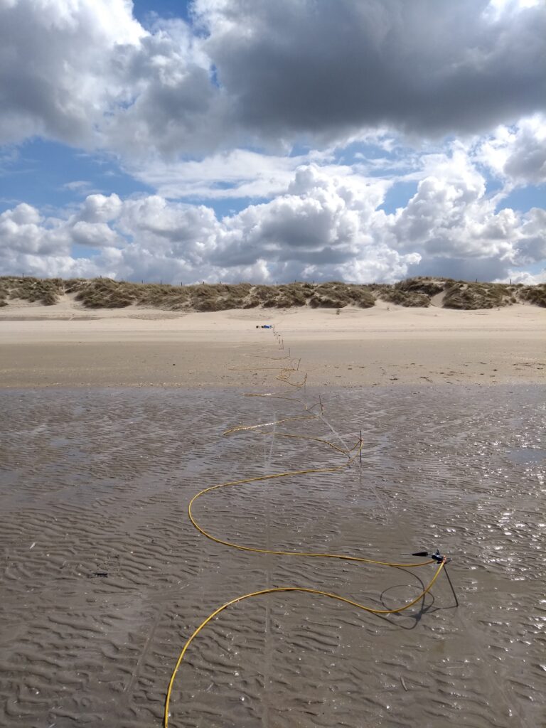
Submarine fresh groundwater discharge imaging through combined resistivity and seismic surveys
Contact: Elien Vrancken
Read more
Groundwater resource distribution in coastal areas is the result of the complex interaction between freshwater recharging on land and seawater. In undisturbed conditions, a natural equilibrium exists leading to typical seawater intrusion (SI) into freshwater aquifers. Fresh groundwater, recharged from rainwater on land, migrates to the sea and results in fresh submarine groundwater discharge (FSGD). At the Belgian coast, the distribution of the fresh/salt water interface is complex due to the Quaternary coastal evolution and anthropogenic factors (e.g., polders). Heterogeneity of lithology can play a major role in the groundwater distribution and the location of the FSGD. The geophysical methods based on resistivity and seismic will be used to investigate the geology and the FSGD of the Belgian coast zone in more detail, building further on Marieke Paepen’s research. Groundwater models of the Belgian coast can then be updated, leading to better predictions of the groundwater distribution.

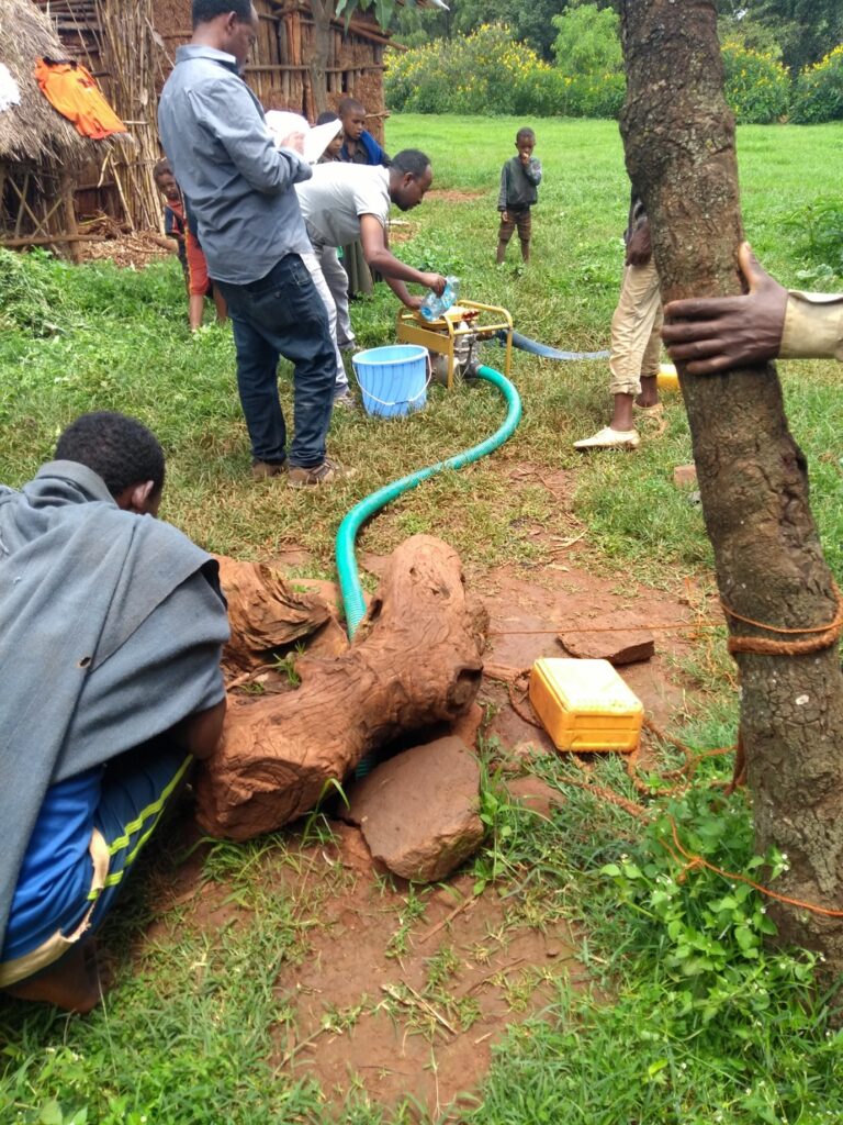
Groundwater-Surface Water Interaction and Recharge-Discharge Systems of Groundwater in the Gilgel Gibe Catchment, Ethiopia
Contact: Fayera Gudu Tufa
Read more
Groundwater (GW)-surface water (SW) interaction and recharge-discharge systems have a remarkable implications in water management, solute transport, and contaminant protection. However, due to its complexity and paucity of observed data, the study of GW-SW interaction is overlooked in developing countries like Ethiopia. In Gilgel Gibe catchment in particular, the current ambitious plan to utilize GW to meet the rapidly increasing demand for industrial, domestic, and irrigation uses would poses stress on the sustainability of water use in the catchment. Therefore, the accurate estimation of GW-SW exchange, GW recharge and its spatiotemporal distribution is indispensable for the sustainability of water resource development in the catchment..
While Soil Moisture Balance (SMB) and Base Flow Separation (BFS) methods are applied to estimate the GW recharge at points and sub-catchments scale, WetSpass and SWAT models are applied to evaluate its spatial and temporal distribution respectively. An integrated model, SWAT-MODFLOW will be applied to estimate the GW-SW fluxes in the catchment. The data required for setup, calibration and validation of the models are collected from both primary and secondary sources. Primary data collection includes drilling well observations, manual and automated piezometric level measurements, and water sampling. The secondary data includes land use land cover, soil, hydrometeorological, and hydrogeological data obtained from different offices and satellite products.
The findings of this study will be essential to improve the conjunctive use of GW and surface; to control contamination of SW caused by GW and vice versa; and to formulate and implement sound policies to minimize undesirable future impacts and devise management alternatives.
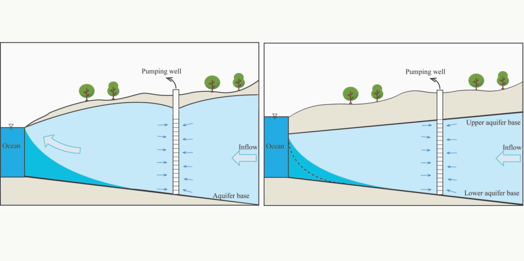
Estimating groundwater resources in coastal aquifers through analytical methods
Contact: Jiazhi Sun
Read more
The sustainable development of fresh groundwater resources is crucial for meeting domestic, agricultural, and industrial water demands in densely populated coastal regions. However, excessive groundwater extraction can cause severe seawater intrusion, thereby depleting valuable freshwater reserves and posing risks to environmental health.
Therefore, quantifying the maximum safe pumping rate and evaluating pumping-induced seawater intrusion are essential for the effective management of coastal aquifers.
This project aims to elucidate the mechanisms of seawater intrusion driven by anthropogenic activities and to develop a rapid, first-order assessment tool for use by practitioners.
Impact of land use land cover and climate change on groundwater recharge at upper Blue Nile Basin, part of Didessa catchment, Ethiopia: Implication for sustainable groundwater management.
Contact: Seifu Kebede Debela
Read more
One of the natural resources for the world’s sustainable growth is groundwater. It serves as an alternative source of water for drinking, irrigating, industrial, energy, economic, and other uses. Despite its purposes, less attention is given for groundwater management. Climate and land use land cover changes are affecting groundwater resources in Ethiopia specifically in Didessa catchment. To overcome these challenges, the research work includes aquifer characterization-based lithology and pumping test data, groundwater chemistry analysis, recharge estimation via multiple approach like SMB, WTF & SWAT-MODFLOW integration, GWF modeling, climate and LULC change impacts on recharge and develop scenario of climate and land use/land cover change for sustainable groundwater management in the catchment. Approach includes desk study, field investigation, experimental analysis and modeling. The anticipated results are crucial to provide basic information nature & types of aquifers, GW qualities issues, GW potential zones, the current status and feature groundwater resources of the catchment under those change essential for sustainable managing groundwater
The Program is joint: NASCERE program collaboration between Jimma University and Ghent University

Geogenic and anthropogenic impact evaluation on Groundwater resources using hydro-physical and hydro-chemical integrated methods. The case of Mekelle City and the surroundings, Tigray, North Ethiopia
Contact: Kaleab Adhena Abera
Read more
The possible geogenic impacts on the groundwater resource quality in the Mekelle area are influenced by the nature of the aquifer and geological structures (faults and joints), which serve as the main conduits for water percolation to the subsurface. The water quality can be affected by contaminants introduced through human activities associated with urban areas, such as heavy metals and chemicals.
To investigate the groundwater quality of the Mekelle area and its surroundings, the project will utilize hydrogeological, hydrochemical, and Vertical Electrical Sounding (VES) geophysical integrated methods.
The project has received funding from VLIROUS (Global Minds Fund Ghent University 2021) and BOF (special research fund).
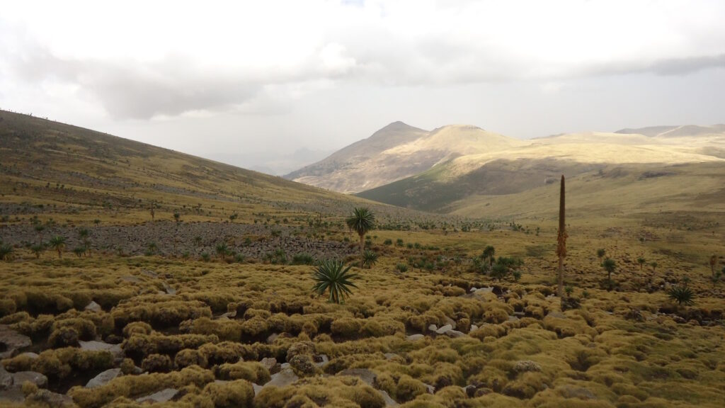
Hydrological system investigation of the highland volcanic geological terrain: the case of Lake Tana Basin, Ethiopia
Contact: Alemu Yenehun Beyene
Read more
The research focuses on groundwater recharge, water balance, aquifer characterization and groundwater flow system modelling, particularly on volcanic rock aquifers. Resulting of his fieldwork, Alemu has gained experience in the monitoring of river discharge and groundwater level, water sampling, and the execution of pumping and slug tests.

Improving salinity estimation from electromagnetic data using Bayesian Evidential Learning
Contact: Arsalan Ahmed
Read more
Accurate subsurface imaging through geophysics is of prime importance for many geological and hydrogeological applications. Among many imaging techniques, application of electromagnetic method is very popular in geophysics for acquiring data set at relevant depth of investigation. But the solution of inversion of EM data is not unique. In this research Arsalan is estimating the uncertainty quantification of salinity of Belgian coast data set, rather than a deterministic solution, by using new stochastic approach called Bayesian evidential learning (BEL) in one dimension.
Hydrological study of Mount Guna, a shield volcano on the Ethiopian Plateau
Contact: Adugnaw Birhanu Zegeye
Read more
The research focuses on land-use modeling, runoff generation, groundwater recharge, and water balance modelling. Fieldwork experience includes installing and collecting meteorological data, river discharge measurements, groundwater level monitoring, and water sampling collection.
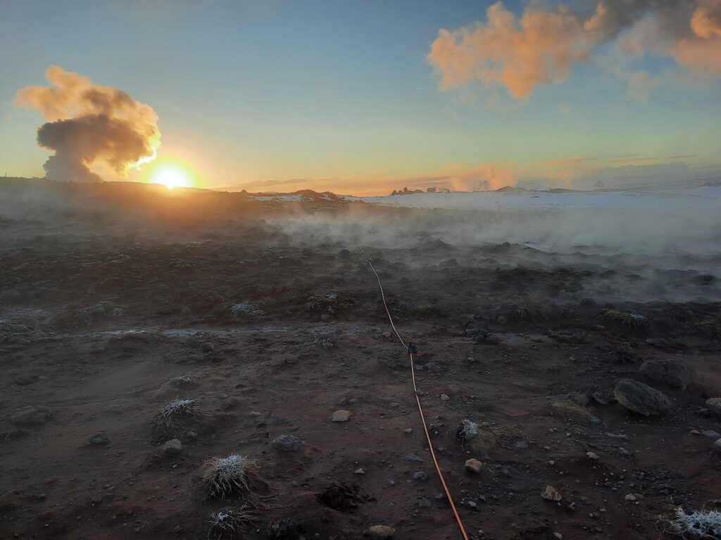
ERupT: Can ERT reveal the dynamics of Volcanic Hydrothermal Systems?
Contact: Lore Vanhooren
Read more
Most volcanoes on Earth host a volcanic hydrothermal system (VHS), which is the zone where the deep volcanic system interacts with the shallow groundwater system. VHS are often related to phreatic- and hydrothermal eruptions, a type of volcanic eruption without a magma component. In contrast to magmatic eruptions, there is no clear pre-eruptive signal related to these hydrothermal eruptions making them very unpredictable and dangerous.
With the ERupT project we want to use geo-electric methods such as Electrical Resistivity Tomography (ERT) and Induced Polarization (IP) to characterize the dynamic behavior of these systems. With the long-term aim to improve hazard assessment in volcanic areas. We chose to use ERT and IP because they are sensitive to changes in salinity, saturation, temperature, and mineral precipitations, all of which can occur in VHS.
The first part of the project includes the monitoring of a high-temperature geothermal system, here an ERT/IP profile in Gunnhuver, Iceland is measured daily since 23/10/2022. The novelty here is the timeframe in which the monitoring happens, volcanic monitoring with ERT is a well-established method but has never before been done daily. The results of the first year (including some auxiliary data) can be found on the dashboard. The second part of the project involves the monitoring of Geysers using the same methods.

Monitoring PFAS contamination and remediation in the subsurface from the pore to the field scale
Contact: Flore Rembert
Read more
The project aims to monitor with geoelectrical acquisition the transport of per- and poly-fluoroalkyl substances (PFAS) in the vadose zone and unlock the potential of biochar particle injection for their remediation in the subsurface. PFAS are long-lasting chemicals globally disseminated in the subsurface. Due to critical adsorption processes, the vadose zone is a preferential retention reservoir for PFAS. However, after decades of pollution, PFAS migration is assessed from groundwater contamination. Only simple models are proposed for the transport and adsorption of PFAS. Applied at the large scale, they neglect small-scale interactions. The proposed project will address this complexity with micro-CT monitoring of porous media contamination with PFAS. X-ray microtomography will be coupled with geoelectrical acquisition to monitor the contamination through scales. In addition, tank experiments will be conducted to upscale the results. The use of biochar for PFAS remediation is a promising technique. Biochar is currently used as an amendment of soils to stabilize PFAS in the vadose zone. However, biochar particle injection is a remediation technique successfully used to adsorb other types of contaminants (e.g., trace elements). The project will investigate the effectiveness of this technique and the capability of geoelectrical acquisition in detecting it.
Rock mechanics and microseismic monitoring in metal mines
Contact: Yihan Zhang
Read more
This research investigates the spatiotemporal evolution of microseismic activity associated with rock mass engineering fractures and focuses on developing a microseismic-based early warning system for rock mass instability. The study integrates microseismic source localization, event clustering analysis, and source mechanism inversion to gain insights into the dynamic behavior of rock masses. By leveraging a combination of statistical approaches and machine learning techniques, predictive models are constructed to facilitate real-time monitoring and early detection of potential instabilities.

Effects of mineral reactions on fracture morphology and reservoir capacity in geothermal development: from both pore scale and field scale
Contact: Jiajie Yang
Read more
Geothermal energy, especially hot-dry rock (HDR), is a promising sustainable energy source due to its abundant reserves and low carbon footprint. Enhanced Geothermal Systems (EGS) provide an effective method for HDR exploitation, with supercritical CO2 showing significant advantages. This study develops thermal-hydraulic-mechanical-chemical (THMC) coupling models to analyze mineral reactions, fracture morphology changes, and heat extraction efficiency. At the pore scale, it examines fracture deformation mechanism and aperture evolution. At the field scale, it explores the effects of mineral reaction and reservoir and extraction parameters on heat extraction. The results will provide insights to optimize EGS strategies and enhance HDR utilization.
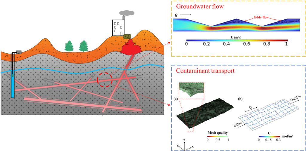
Investigation of groundwater flow and contaminant transport in rough fracture networks, combined with the analysis of parameter uncertainty
Contact: Kehan Miao
Read more
Kehan’s research focuses on investigating water flow and contaminant transport in fracture networks, with a strong emphasis on uncertainty analysis. He also studies the interactions between surface water and groundwater and conducts uncertainty assessments of hydrogeological parameters to better understand subsurface processes.

Numerical modelling of groundwater dynamics and transport of emerging contaminants in the light of climate change
Contact: Ivana Perović
Read more
Ivana’s PhD project looks at how climate change affects groundwater recharge and flow, and what that means for the transport of emerging contaminants such as pharmaceuticals in intergranular aquifers. The goal is to get a better understanding of how extreme climate conditions shape contaminant behaviour and groundwater quality, and to assess the risks this poses for drinking water resources.
The research combines fieldwork and groundwater monitoring with numerical modelling. Groundwater flow and contaminant migration will be simulated using MODFLOW 6 and transport modules under different climate scenarios. The study focuses on the Krško aquifer in Slovenia, an alluvial aquifer that is both highly vulnerable and important for public supply. Ongoing monitoring of groundwater levels and water quality, together with targeted analyses of pharmaceuticals and other emerging contaminants, are the basis for model calibration.
By linking climate projections with contaminant transport, the aim of the research is to give new insights into how groundwater systems may respond in the future. The outcomes will help improve predictions of groundwater vulnerability and support more sustainable management of water resources under changing climate conditions.
The project is funded by the Slovenian Research Agency (ARIS) and carried out as a joint PhD between Ghent University and University of Nova Gorica in Slovenia.
picture: passive samplers